|
Updated: October 11th 2003
This is a description of how the mapping scale and
placement works for a battle. At the end is a link to a program that uses
these equations and will automatically make an annotated map of any objects
you want to see.
First, unpack a map and go to the bf1942\levels\somebattlename
directory for the battle. We'll use the bf1942\levels\Anzio files
as an example.
First, in Init\Terrain.con is the line:
GeometryTemplate.WorldSize 2048
The number is the scale of the world, how many meters
wide and high it is. However, this number can be overridden by a token
in Init.con:
Game.SetActiveCombatArea 512 768 1280 1280
The last two numbers are the X and Z scales (which
are always the same, since all maps are square). So now the scale is 1280.
The first two numbers are also important, they are the offsets for X and
Z. X and Z are the overhead map's axes, X goes to the right and Z goes
up from the lower left corner of the map. (I use X and Z here, since the
position of objects is in X/Y/Z)
So let's say you want to know where an object is on
the map. In the various .con files such as StaticObjects.con, conquest\ControlPoints.con,
conquest\ObjectSpawns.con, and conquest\SoldierSpawns.con
there is data like this:
  Object.Create ALLIES_BASE
  Object.AbsolutePosition 1096.07/32.5711/1156.19
(from conquest\ControlPoints.con). The absolute
position is in terms of the offsets and scales already given. The first
number is the X coordinate, the second is the altitude of the object,
and the third the Z coordinate. Here's how to compute the map location
of the object:
  map_x = (Object_x - offset_x) / scale
  map_z = (Object_z - offset_z) / scale
So, with the numbers we have so far:
  map_x = (1096.07 - 512) / 1280 = 0.4563
  map_z = (1156.19 - 768) / 1280 = 0.3033
On an edge scale of 0 to 1, go 0.4563 to the right
and 0.3033 up from the lower left corner and you are at one of the Allied
control points. To convert to map grid coordinates (which are from the
upper left corner), you would do this:
  coord_x = letter "A" + integer(map_x * 8)
  coord_z = 8 - integer(map_z * 8)
for example:
  coord_x = letter "A" + integer(0.4563 * 8) = "A" + 3 = "D"
  coord_z = 8 - integer(0.3033 * 8) = 8 - 2 = 6
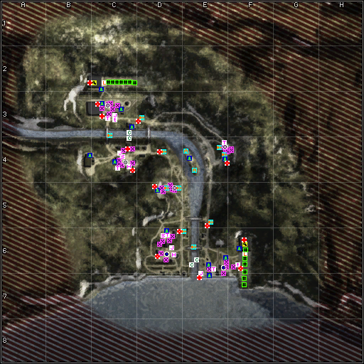
So this base is at D6, which is indeed the case, and
can be confirmed on the map at the end of this page.
Perl Makemap Program
The Perl program makemap.zip
uses this conversion process to create annotated maps of any battle in Battlefield
1942 or total mod (currently "Desert Combat" and "Eve of Destruction" are
supported, but the program is easy to extend). What this program does is
to read in object data and minimap from a level and create an overhead map
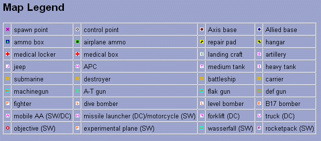
at a user-specified resolution, annotated with icons as desired. Spawn points,
flags, repair pads, ammo boxes, and other data can be displayed. The program
also dumps the coordinates of all objects found in the scanned files.
As an example, the Secret Weapons maps at the
PlanetBattlefield
Intel site were made with this program. The output map is in .PPM
format, which can be read by the free Irfanview
image viewer, among others. I recommend converting this output PPM file
to 24-bit color PNG, as GIF has too few colors and the icons will often
change horribly, while JPEG will blur the icons.
You can run the program by doing the following:
- Install a Perl distribution, if you do not have
one. ActiveState's
Perl Distribution is free and high-quality.
- Extract the makemap.zip
files to some directory, say C:\perlprogs.
- Extract the level's .rfa file you want to map to
a directory. This is done by using the MDT's winRFA.exe program,
at C:\Program Files\EA GAMES\Battlefield 1942\Mod Development Toolkit\Tools\RFA
Tools\winRFA.exe and opening up a level .rfa file, for example C:\Program
Files\EA GAMES\Battlefield 1942\Mods\XPack1\Archives\Bf1942\Levels\Anzio.rfa.
You'll also, in this example, want to unpack Anzio_003.rfa afterwards;
this is a patch file that should be overlaid on top of the original
unpacked files.
- Open up a command prompt window. Click "Start |
Run..." and type "cmd.exe".
- In the command window go to the directory where
you extracted the data (e.g. "cd C:\bf1942extract\Bf1942\Levels\Anzio").
You're ready to run the perl script. Type:
perl c:\perlprogs\makemap.pl > mapdata.txt
The map is put in Anzio.ppm, which you can
then view and convert with Irfanview
or another image viewer. The mapdata.txt file contains the placement
of all objects in the level (even if not visible). By default, the makemap.pl
program makes a 512x512 map with important objects shown. For a higher resolution
version of the map that also includes soldier spawn points, repair pads,
and airfield resupply points, do:
perl c:\perlprogs\makemap_full.pl
The data will stream by instead of getting stored
in a file. At the end, Anzio2.ppm is created. Note that this is
a different map name; the "2" comes from what the "$mapscale" variable is
set to inside the program, if not equal to "1". Other than the options and
comments changed at the tops of the files, makemap.pl and makemap_full.pl
are identical code.
By default, the program searches the Conquest
directory for the object spawn files, and also includes any Objective
Mode objectives. You can map other types of battles, by setting "$battletype"
to "objectivemode" or "singleplayer" or other battle type; see the top
of the program for more options.
If icons overlap, they will be normally be shifted
in a reasonable manner so that their overlap is minimized and they are
all readable (actually, soldier spawn icons are ignored in this process,
since they are so numerous and relatively unimportant). This option can
be turned off, and icons can be made semi-transparent so that it is clearer
when two icons overlap. There are a number of other options available,
such as the output map size, icon transparency, etc.; again, read the
documentation at the top of the program. It is also fairly straightforward
to edit the program to scan for other types of objects (say, all the trees)
and display their locations, and to add new icons.
That said, this program can be fooled. It keys off
of the various *Templates.con files' "create" names for weapon spawn points,
control points, etc. If the designer uses non-standard names for these
points, the program may ignore or miscategorize these. For example, on
the Telemark map's ObjectSpawnTemplates.con file it says:
  ObjectTemplate.create ObjectSpawner heavytankspawner
  ObjectTemplate.setObjectTemplate 2 sherman
  ObjectTemplate.setObjectTemplate 1 panzeriv
However, Shermans and Panzer IV's are not normally
called heavy tanks on all other maps, they're called light or medium tanks.
Because of this different naming scheme, heavy tank icons would incorrectly
be shown on this map. My solution is to simply make a special version of
makemap.pl and edit it to treat heavy tanks as being medium tanks.
This is trivial, it involves changing the lines:
    } elsif ( $showland && $fld[1] =~ /heavytankspawner/i ) {
        &DRAWICON( $subfld[1], $subfld[2], %hvytankicon);
to
    } elsif ( $showland && $fld[1] =~ /heavytankspawner/i ) {
        &DRAWICON( $subfld[1], $subfld[2], %medtankicon);
i.e. the icon drawn is changed.
The minimap file reader in this program is fairly
elaborate, reading in a fair assortment of DDS format files. If you get
incorrect results for the output map, such as strange colors or bands,
it is likely that the minimap (textures\ingamemap.dds) is in a
DDS format that is not supported.
Here is a sample custom map, of Anzio, with all objects
shown and with shifting done so all icons are visible.
|